What Is A Food Desert?
A food desert is a geographical area where it is difficult to buy healthy, nutritious food at an affordable price. Food deserts include areas where travel to a grocery store is difficult, and in areas where healthy food may be available, but at an unaffordable price.
Indianapolis has several areas that are considered a food desert. In fact, in 2015, the USDA ranked Indianapolis the worst for food deserts in the country.
Learn more: What Are Food Deserts?
Fast Facts About Food Deserts in Indianapolis
- 200,000 people in Indianapolis live in a food desert. That is one-fifth of Indianapolis residents (SAVI 2019).
- 71 percent of Marion County census tracts have low food access, and 42 percent of census tracts in Marion County are low income and low access (SAVI 2018).
- The number of people in food deserts in Indianapolis has risen by 10% since 2016 (SAVI 2019).
Why Are There Food Deserts In Indianapolis?
Food deserts are a socio-economic problem that tend to occur in specific neighborhoods as a result of a lack of proper aid and investment in that neighborhood.
Food deserts are found in Indianapolis in neighborhoods with high poverty levels. These areas have lower access to transportation, making it more difficult to get to a grocery store.
Food deserts are also disproportionately found in areas where the residents have lower levels of education and high unemployment rates. Areas with food deserts also have high rates of abandoned or vacant buildings.
Food deserts are more likely to occur in primarily Black communities in Indianapolis. A national 2014 study showed that even in areas of equal poverty, Black communities are less likely than communities of other races to have access to grocery stores and fresh food (Bower et al. 2014).
Where Are There Food Deserts In Indianapolis?
Areas in Indianapolis with low-income and low-access to stores, as well as low vehicle access are food deserts.
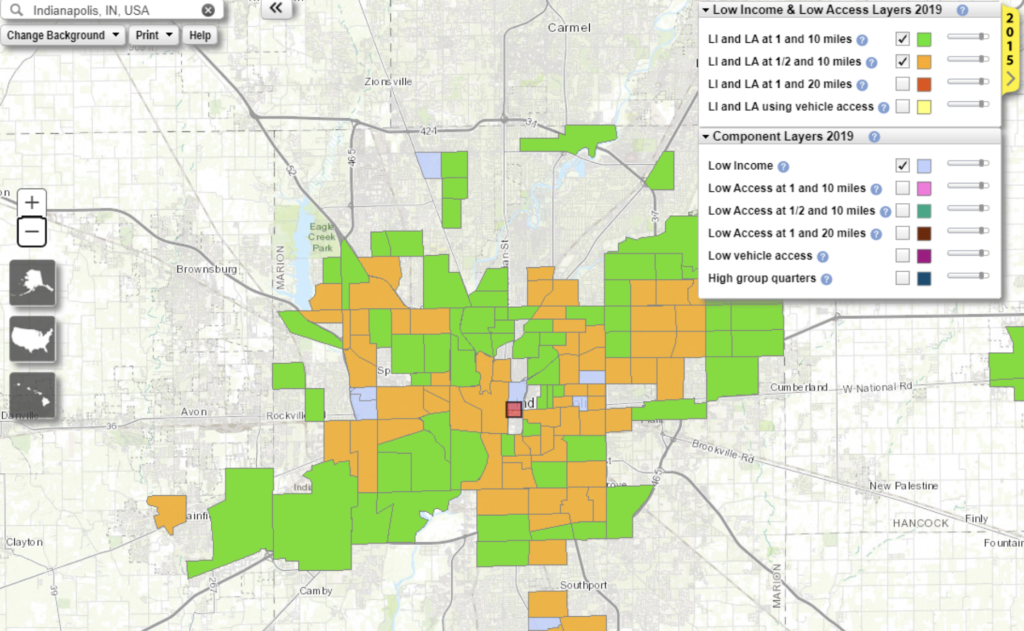
This USDA map provides an overview of where food deserts are located in the city of Indianapolis and surrounding areas. Any area showing orange or green is a food desert. All of these areas are low-income areas as well.
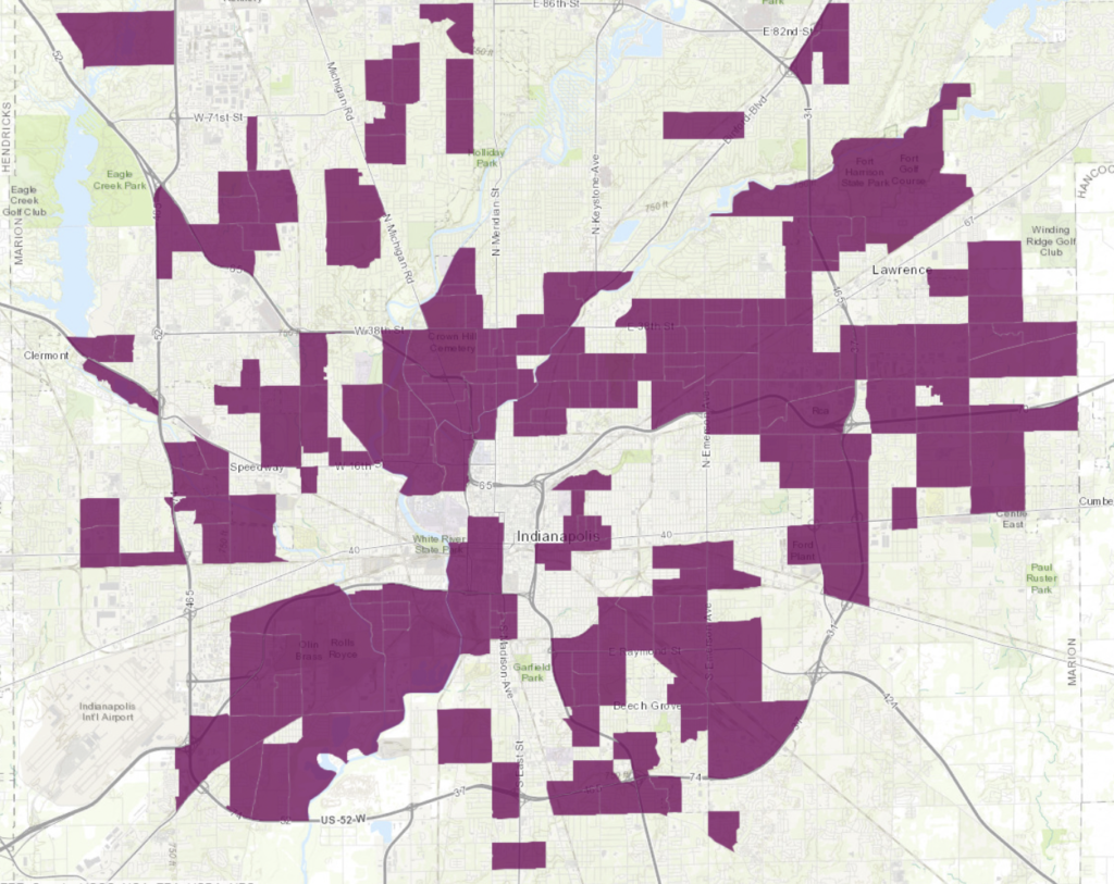
The map below provides a more zoomed-in view of food deserts in Indianapolis (shown in purple).
This map was created by researchers at Indiana University’s SAVI Community Information System, who found that when using local, up to date data, food deserts in Indianapolis are actually higher than the USDA estimates (the orange and green map above).
Source
The largest food deserts are located in northwest and northeast areas, southwest and southeast areas, and the Far Eastside.
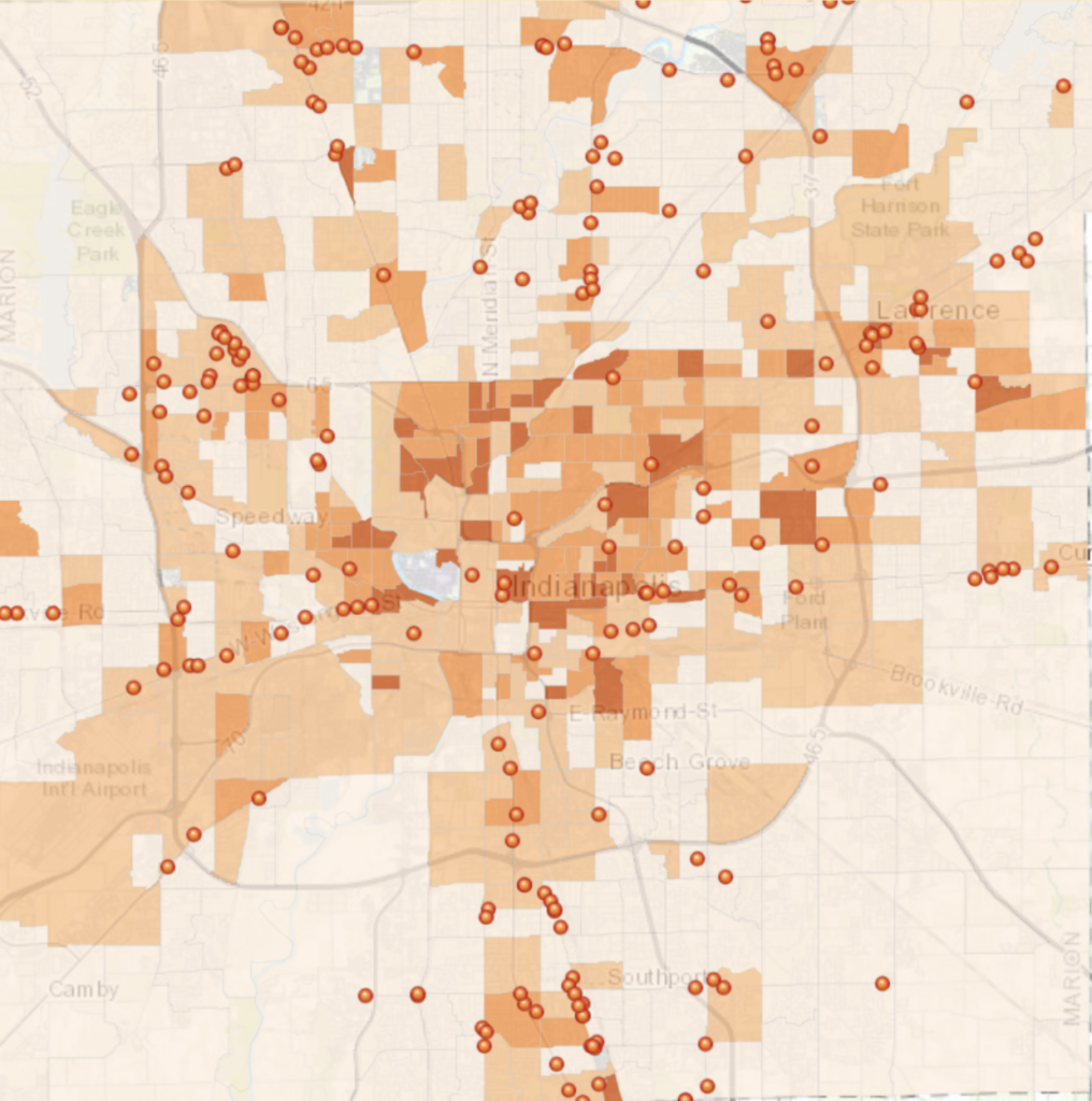
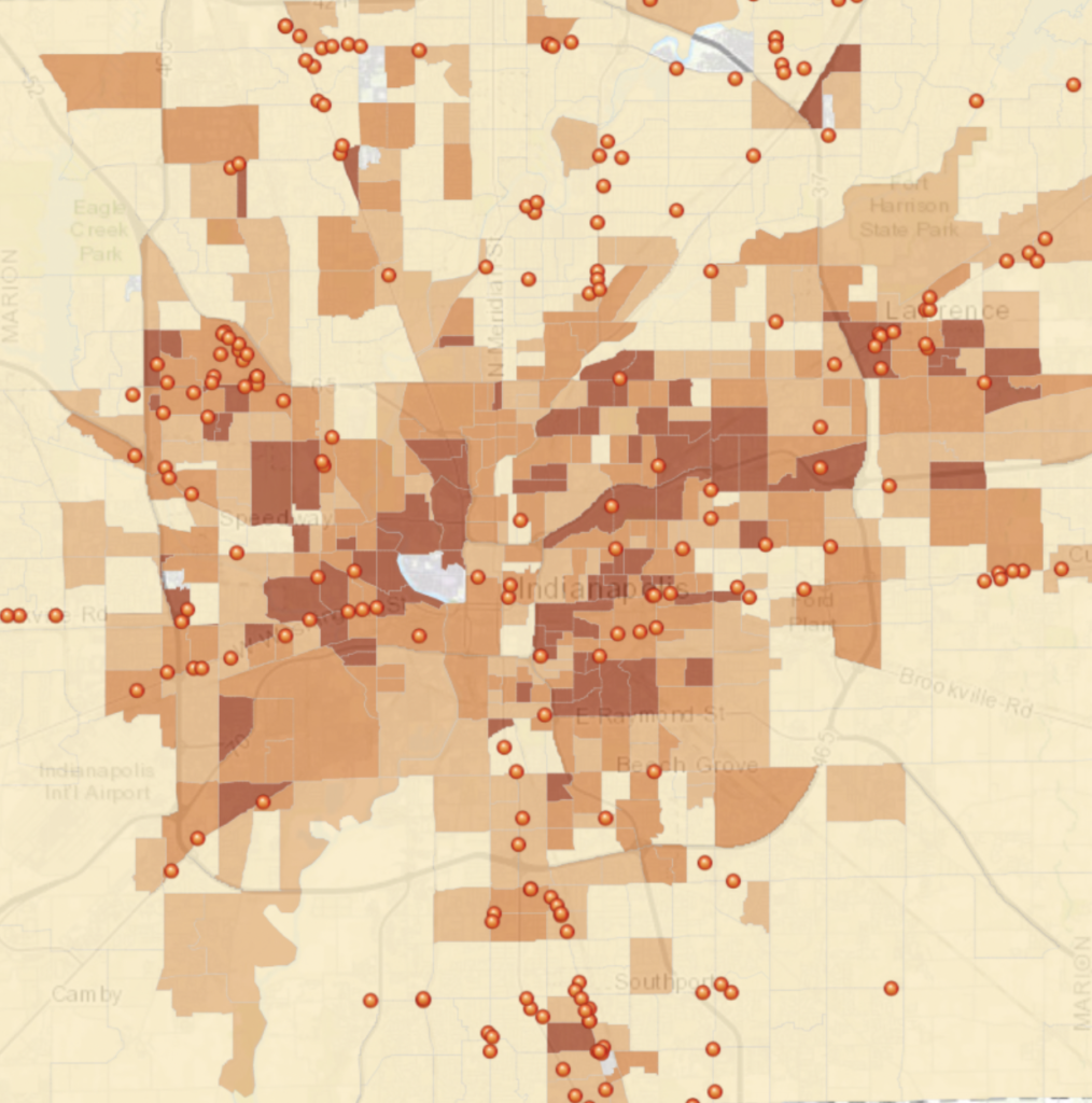
Food deserts also occur in areas without transportation that accesses a grocery store. In Indianapolis, 10,500 households live without a car, and with no grocery store accessible by bus. This may be referred to as a “transit food desert.”
The map below shows the percentage of households without a car (darker orange = fewer cars) as well as the location of grocery stores (orange dots). Note that many areas with few household cars also are far from grocery stores. These are food deserts.
Source
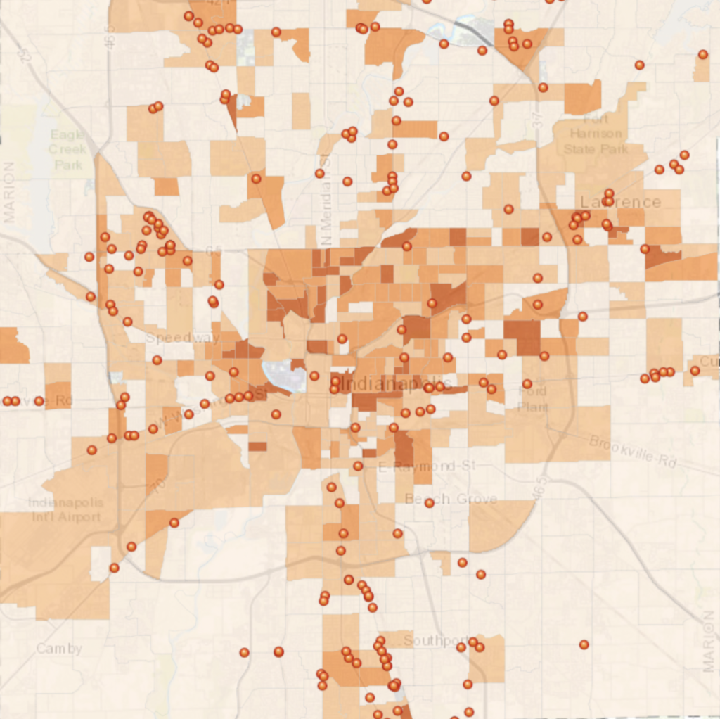
Food deserts also occur in low-income areas without grocery stores or where residents cannot afford healthy food, even if it is available. The map below shows poverty rates in Indianapolis (darker orange = higher poverty rates), as well as grocery stores (orange dots).
Areas with high poverty and few grocery stores are food deserts. Note the overlap of areas with high poverty and areas with few cars. These make up the food deserts shown in purple on Map 1.
Source
Solutions
The first step in disrupting food deserts in Indianapolis is researching where food deserts exist. Researchers through Indiana University have carefully mapped the location of food deserts in Indianapolis across a variety of factors, including income, grocery location, car access, and households receiving SNAP benefits (SAVI 2019). Their report shows that food deserts in Indianapolis follow the classic characteristics of food deserts, as they occur in areas of low-income and in primarily Black neighborhoods.
Once food deserts are identified, multiple collaborative solutions are needed to them.
Increasing the Number of Grocery Stores
Some efforts have focused on increasing the number of grocery stores within Indianapolis. This would help make fresh foods more convenient to residents in food deserts that currently have to travel long distances to grocery stores.
For example, Colorado’s Supermarket Tax Credit for Underserved Areas Act aims to incentivize grocery stores to open in food deserts by offering a tax credit for selling fresh food.
Building more grocery stores must be undertaken carefully, as simply increasing the overall number, rather than placing them thoughtfully, does not solve the problem. Since 2016, more grocery stores have opened in Indianapolis, but they are clumped together, and the number of people living in food deserts has still increased (SAVI 2019).
Increasing the number of grocery stores in food deserts is also just a start, as simply increasing grocery stores is not enough on its own. Even if healthy food is available at grocery stores, people in low-income areas may not be able to afford to buy it.
For example, the map below shows the percentage of households receiving federal Supplemental Nutrition Assistance Program (SNAP) benefits in Indianapolis, as well as the location of grocery stores. This lines up closely with areas of food deserts. Grocery stores in food deserts must accept federal food assistance programs like SNAP and WIC.
Source
Solutions that focus on decreasing food prices or providing financial assistance must come hand in hand with increased grocery store numbers.
Increased Access To Vehicles And Other Public Transportation Systems
In addition to creating more healthy food options locally, increasing transportation options can help reduce food deserts.
One method to increase transportation to grocery stores is to build up better public transportation. This may include adding a bus stop or even creating a shuttle system within the neighborhood.
Additionally, Lyft ride sharing created the Grocery Access Program to discount the cost of rides to grocery stores. This program has been piloted successfully in Washington D.C. in 2019, and has expanded to several cities since then. A similar program in Indianapolis’s food deserts would aid residents in accessing inconvenient grocery stores.
Urban Farming and Community Gardens
Urban farming and community gardens offer a community-based approach to making fresh produce available to Indianapolis residents.
For example, the city of Indianapolis runs two community gardens. Residents can contact the city to reserve a plot. This brings community engagement to the issue of nutritious food and provides produce.
Urban gardens (privately owned gardens in the city) are becoming more and more popular in Indianapolis, partially due to Mayor Greg Ballard’s urban gardens program.
Other Solutions
Other solutions that could help eliminate food deserts in the city of Indianapolis include:
- Financial incentives and support for neighborhood-based grocery stores and farmers markets with discounted prices
- Increased financial assistance for residents of food deserts to buy food
- Increased public health education to encourage healthy eating
Some of these solutions are already being implemented.
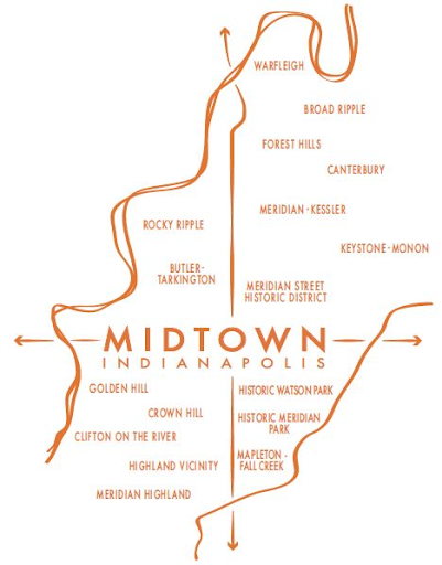
Case Study: Midtown
Midtown is an area of Indianapolis that comprises 12 square miles and 17 neighborhoods. It lies between White River and Fall Creek.
Midtown is considered a food desert. This is due to lower access to transportation, fewer grocery stores, and lower incomes. Many grocery stores in the area have closed, such as Double 8 foods, which closed its two midtown locations in 2015 after serving the area for 58 years.
Like other food deserts in Indianapolis, Midtown follows many of the classic characteristics of where food deserts are most commonly found. Midtown residents have lower education and income than the rest of Indianapolis, there are more vacant homes, and many neighborhoods are communities of color.
- The median household income in Midtown is $41,620 compared to $47,873 in the rest of Indianapolis.
- Only 76% of Midtown residents have attended some college compared to 85.5% of Indianapolis residents.
- There is a higher percentage of vacant homes in Midtown (11.2%) compared to vacant homes in Indianapolis (9.1%). Food deserts often occur in areas with higher rates of vacant homes.
- Higher percentages of Midtown residents, especially north of 42nd street, are Black or Latino.
These statistics provide an overview of the Midtown area. Of course, each neighborhood within the 12 mile area has its own unique characteristics.
Many solutions have been suggested to increase Midtown residents’ access to healthy food.
For example, after recent grocery store closures in the area, the MLK Center worked with the Indianapolis Fire Department to create a shuttle service to nearby grocery stores. The program passed out fliers at dollar stores that did not sell fresh food in an attempt to inform residents of the ability to take advantage of the shuttles.
Another example of a solution bringing fresh food to Midtown is the Buckhart Community Garden in Rocky Ripple. The garden was established in 2001.
More solutions, including increased affordable grocery stores and more transit options, are necessary to truly disrupt the food desert in Midtown, Indianapolis.